The World’s 20 Longest Rivers
The World’s 20 Longest Rivers
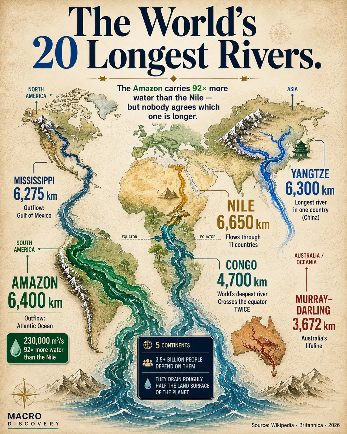
The Nile stretches 6,650 km through 11 countries. The Amazon carries more water than the next seven longest rivers combined. The Congo is deeper than a skyscraper. And nobody can agree which one is actually longest. These rivers are not just geography — they are civilization itself.
Every river on this list has shaped a civilization. The Nile gave Egypt. The Yangtze gave China its industrial spine. The Amazon holds the largest rainforest on Earth. The Mekong feeds 60 million people. Together these 20 rivers drain roughly half the land surface of the planet — and measuring them precisely turns out to be one of geography’s oldest unsolved problems.
- The Nile flows through 11 countries — more than any other river on Earth — from Uganda and Tanzania in the south to Egypt’s Mediterranean coast in the north.
- The Amazon is the largest river by water volume by an enormous margin — its discharge of 230,000 m³/s dwarfs the Nile’s 2,490 m³/s. Whether it is also the longest is genuinely disputed.
- The Yangtze is the longest river flowing entirely within one country — 6,300 km inside China, making it the backbone of the world’s most populous nation.
- The Congo is the deepest river on Earth, reaching depths exceeding 220 metres — deeper than most skyscrapers are tall. It is also the only major river to cross the equator twice.
- Asia dominates the top 20 with 8 entries — more than any other continent — reflecting the continent’s vast landmass and high mountain sources in the Himalayas and Tibetan Plateau.
| # | River System | Continent | Length (km) | Countries |
|---|---|---|---|---|
| 1 | Nile–White Nile–KageraOutflow: Mediterranean Sea · ⚠ length disputed — see Amazon |
Africa | 6,650 | 11 countries Most countries |
| 2 | Amazon–Ucayali–MantaroOutflow: Atlantic Ocean · ⚠ may be longer than Nile by some measures |
S. America | 6,400 | Brazil, Peru, Bolivia, Colombia + 3 Largest by volume |
| 3 | Yangtze (Chang Jiang)Outflow: East China Sea |
Asia | 6,300 | China only Single country |
| 4 | Mississippi–Missouri–JeffersonOutflow: Gulf of Mexico |
N. America | 6,275 | USA (98.5%), Canada (1.5%) |
| 5 | Yenisei–Angara–SelengaOutflow: Kara Sea (Arctic) |
Asia | 5,539 | Russia (97%), Mongolia |
| 6 | Yellow River (Huang He)Outflow: Bohai Sea |
Asia | 5,464 | China only Single country |
| 7 | Ob–IrtyshOutflow: Gulf of Ob (Arctic) |
Asia | 5,410 | Russia, Kazakhstan, China, Mongolia |
| 8 | Río de la Plata–Paraná–Rio GrandeOutflow: Atlantic Ocean |
S. America | 4,880 | Brazil, Argentina, Paraguay, Bolivia, Uruguay |
| 9 | Congo–Lualaba–ChambeshiOutflow: Atlantic Ocean |
Africa | 4,700 | DRC, CAR, Angola, Rep. of Congo + others World’s deepestCrosses equator ×2 |
| 10 | Amur–Argun (Heilong Jiang)Outflow: Sea of Okhotsk |
Asia | 4,444 | Russia, China, Mongolia |
| 11 | LenaOutflow: Laptev Sea (Arctic) |
Asia | 4,400 | Russia only Single country |
| 12 | Mekong (Lancang Jiang)Outflow: South China Sea |
Asia | 4,350 | China, Myanmar, Laos, Thailand, Cambodia, Vietnam |
| 13 | Mackenzie–Slave–Peace–FinlayOutflow: Beaufort Sea (Arctic) |
N. America | 4,241 | Canada only Single country |
| 14 | NigerOutflow: Gulf of Guinea |
Africa | 4,200 | Nigeria, Mali, Niger, Algeria, Guinea + others |
| 15 | Brahmaputra–Yarlung TsangpoOutflow: Bay of Bengal (via Ganges) |
Asia | 3,969 | India (58%), China (20%), Nepal (9%), Bangladesh |
| 16 | Murray–DarlingOutflow: Southern Ocean |
Australia | 3,672 | Australia only Single country |
| 17 | Tocantins–AraguaiaOutflow: Atlantic/Amazon Delta |
S. America | 3,650 | Brazil only |
| 18 | VolgaOutflow: Caspian Sea (endorheic basin) |
Europe | 3,645 | Russia only — Europe’s longest river |
| 19 | Shatt al-Arab–Euphrates–MuratOutflow: Persian Gulf |
Asia | 3,596 | Iraq, Turkey, Syria, Iran |
| 20 | Madeira–Mamoré–GrandeOutflow: Amazon River |
S. America | 3,380 | Brazil, Bolivia, Peru |
Source: Wikipedia “List of river systems by length” (primary table, directly verified). Cross-check: Encyclopædia Britannica · Visual Capitalist (Feb 2026, citing Britannica). Click column headers to sort.
All lengths are approximations. River systems are measured from the most distant source tributary to the mouth. Different methodologies produce different figures — see data note above. Rankings 15–20 may vary between sources depending on measurement method used.
The Nile vs the Amazon — A Dispute That Has Never Been Settled
For most of recorded history, the Nile has been considered the world’s longest river. At 6,650 km, it flows from the lakes and highlands of Uganda and Tanzania northward through Sudan and Egypt to the Mediterranean — crossing 11 countries, more than any other river on Earth. But in 2007 and 2008, Brazilian and Peruvian scientists claimed the Amazon was actually longer — up to 6,992 km — by tracing its source further into the Peruvian Andes and adding a tidal canal through the Pará estuary at its mouth.
A peer-reviewed paper published in 2009 pushed back, measuring the Nile at 7,088 km and the Amazon at 6,575 km using satellite analysis. As of 2020, Encyclopædia Britannica states that the Amazon’s length “remains open to interpretation.” The honest answer is that both rivers are so close in length that the true ranking depends entirely on where you start and stop measuring — and no single authoritative body exists to make that call definitively. This article uses the traditional figures, which put the Nile first.
Length vs Volume — Two Very Different Ways to Be the Biggest
The Nile may be longer, but the Amazon is overwhelmingly larger in every other sense. The Amazon’s discharge at its mouth is 230,000 cubic metres per second — roughly 92 times the Nile’s 2,490 m³/s. The Amazon basin covers 7 million square kilometres — more than twice the Nile’s drainage area. The Amazon rainforest surrounding it holds approximately 10% of all species on Earth. In flood season, the river widens to 50 kilometres in some stretches — closer to an inland sea than a river.
The Nile achieves its length partly because it flows through some of the driest land on Earth. Much of its water evaporates or is consumed before reaching the sea. The Amazon achieves its volume because it flows through the wettest major basin on the planet. These are not competing rivers — they are rivers that have perfected completely different ways of being extraordinary.
Asia Has Eight Rivers in the Top 20 — and Good Reasons for It
More than a third of this list flows through Asia. The Yangtze (#3), Yellow River (#6), Ob–Irtysh (#7), Yenisei (#5), Amur (#10), Lena (#11), Mekong (#12), and Brahmaputra (#15) are all Asian rivers. The reason is structural: Asia contains the Tibetan Plateau — the highest large landmass on Earth, at an average elevation of 4,500 metres — and the Himalayan mountain range. High altitude combined with enormous snowmelt creates the source conditions for the world’s longest rivers.
The Mekong alone flows through six countries — China, Myanmar, Laos, Thailand, Cambodia, and Vietnam — feeding around 60 million people in its lower basin. The Brahmaputra travels under a different name in each country: Yarlung Tsangpo in Tibet, Siang in Arunachal Pradesh, Brahmaputra in Assam and Bangladesh. It is the same river wearing different identities as it descends from the roof of the world to the Bay of Bengal.
The Congo: Short Enough to Miss the List’s Top Half, Strange Enough to Define It
At 4,700 km, the Congo ranks ninth by length. But it is the most unusual river on this list by almost every other measure. It is the world’s deepest river — reaching depths exceeding 220 metres in the Congo Canyon, far deeper than any other river on Earth. It crosses the equator twice — the only major river to do so. Its basin is sometimes called the “second lung of the earth” alongside the Amazon rainforest, and the Congo Basin holds the world’s second-largest tropical rainforest.
The Congo’s discharge of 41,400 m³/s makes it the second-largest river by volume after the Amazon — despite being only ninth by length. The reason is geography: the river drains an enormous, bowl-shaped basin surrounded by high ground on almost every side, concentrating rainfall into a single narrow outflow point near Kinshasa. The river drops 270 metres in its final 350 km — a gradient so steep it generates enormous hydroelectric potential and prevents ocean-going ships from reaching the interior.
The Volga and the Niger — Two Rivers With Nowhere Normal to Go
The Volga, Europe’s longest river at 3,645 km, does something unusual for a major river: it flows into an inland sea. The Caspian Sea has no outlet to any ocean — it is an endorheic basin, meaning water can only leave by evaporation. The Volga is Russia’s historic “national river,” the spine of medieval trade routes, and the site of the Battle of Stalingrad. And yet it never reaches the ocean.
The Niger’s peculiarity is geometric. At 4,200 km, it is Africa’s third-longest river — but it travels in a shape that makes no geographic sense at first glance. It rises in Guinea, just 240 km from the Atlantic coast, then turns northeast into the heart of the Sahara Desert — apparently away from any sea — before curving southeast and finally south, reaching the Gulf of Guinea in Nigeria. This “boomerang” shape is the result of ancient drainage patterns formed when the Sahara was wetter than it is today. The river’s path traces a landscape that no longer exists.
- Wikipedia — “List of river systems by length” (primary table, directly verified June 2026)
- Encyclopædia Britannica — “World’s Longest Rivers” (cross-check source)
- Visual Capitalist — “Mapped: The 15 Longest Rivers in the World” (Feb 2026, citing Britannica)
- International Journal of Digital Earth (2009) — peer-reviewed river length measurements (Nile 7,088 km, Amazon 6,575 km) — cited in Wikipedia
- Encyclopædia Britannica (2020) — Amazon length “remains open to interpretation and continued debate”