The Last Ungoverned Spaces
There are still places on Earth with no government, no law, and no map. Here is where they are.
The unclaimed land is a mapped desert of about 2,060 km². The unmapped part is the seabed, 28.7% charted. The high seas have a treaty.
Three numbers
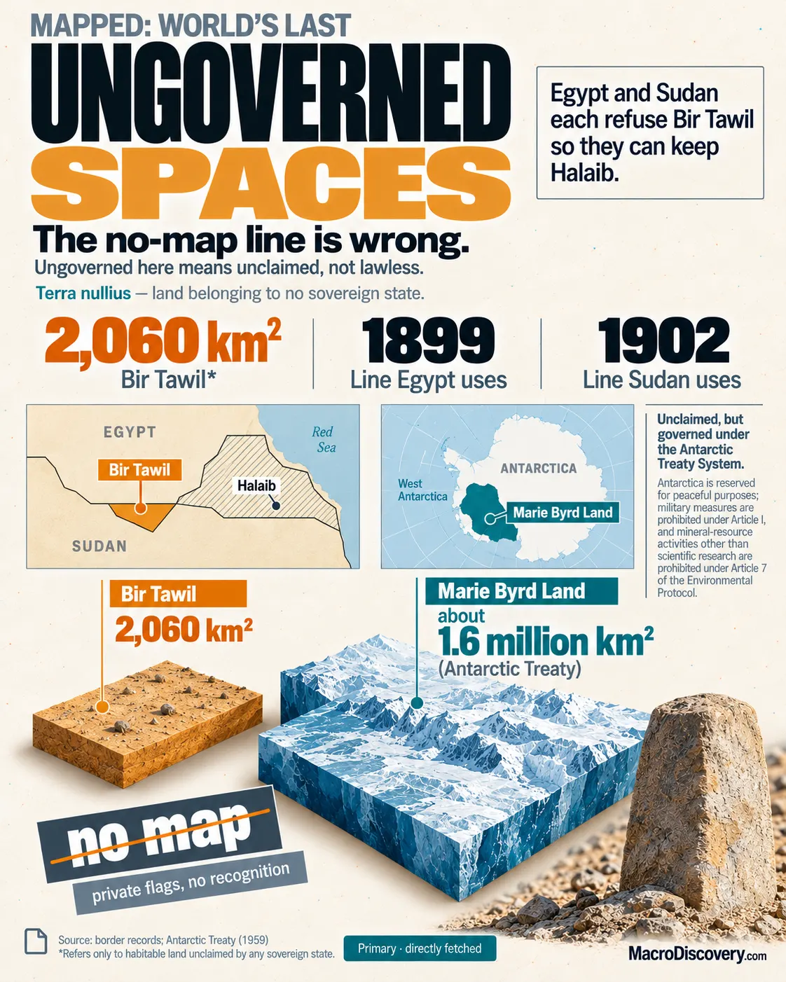
- About 2,060 km² — Bir Tawil, the desert Egypt and Sudan both refuse. It is on the map. Source: border records.
- 28.7% — share of the ocean floor charted in 2026, about 104 million km². Source: Seabed 2030.
- A treaty — Marie Byrd Land is unclaimed by a state, and the Antarctic Treaty freezes claims. Source: Antarctic Treaty.
What the data shows
A common claim is that places remain on Earth with no government, no law, and no map. The fact is that the three gaps are different, and only one of them is unmapped. The land neither neighbor claims is Bir Tawil, about 795 square miles, or 2,060 km², between Egypt and Sudan. The 1899 line gives Egypt the Hala’ib Triangle and leaves Bir Tawil to Sudan. The 1902 line does the reverse. Each state keeps the line that holds Hala’ib, so each refuses Bir Tawil. The patch is sand and dry hills. It appears on ordinary maps. Private claimants, including a Virginia farmer who planted a flag in 2014 and called it a kingdom, are not recognized. An empty desert is not a society without law.
The other unclaimed land is ice. Marie Byrd Land, about 620,000 square miles, is the largest sector of Antarctica no state has claimed. The Antarctic Treaty freezes claims and sets rules for science and activity. It is not a legal void, and it is not habitable. Bir Tawil has no matching treaty. It is also not a settlement. A map that paints both as lawless has merged a diplomatic gap with a frozen continent.
The unmapped part is the floor of the sea. Seabed 2030 said 28.7% of the ocean floor was charted in 2026, about 104 million km², after nearly 5 million km² were added in a year. About 71% of the floor is still not mapped to that standard. The water above it is not ungoverned. A ship on the high seas keeps the law of its flag state. The UN Convention on the Law of the Sea sets zones, transit, and the seabed beyond national shelves. An uncharted floor is a missing survey. It is not a place with no law, and it is not the desert between Egypt and Sudan.
The high seas have flag-state law and a convention. An uncharted floor is not a legal void.
| Count | Figure | What it is |
|---|---|---|
| Bir Tawil | about 2,060 km² | Claimed by neither. On the map |
| Marie Byrd Land | about 1.6 million km² | Unclaimed. Treaty freezes claims |
| Ocean floor mapped | 28.7% | 104 million km². 2026 |
| Added in a year | about 5 million km² | Still about 71% uncharted |
| Private flags | not recognized | Including a 2014 micronation |
How it was measured
Bir Tawil’s size is the polygon between the 1899 and 1902 lines, about 795 square miles. A claim by a private person is not a state. Recognition is what other governments do, and they have not done it. Marie Byrd Land’s status is the absence of a state claim plus the Antarctic Treaty, which freezes the ones that exist elsewhere on the continent.
Seabed 2030 counts bathymetry contributed to the GEBCO grid, not a satellite picture of the sea surface. The surface has long been mapped. The floor has not. Law of the sea is a treaty regime. It does not require a charted floor to apply.
What it means
It is settled that Bir Tawil is claimed by neither neighbor, that 28.7% of the ocean floor was charted in 2026, and that Marie Byrd Land sits under the Antarctic Treaty. It is not settled that any of these is a place with no law and no map. Use 2,060 km² for the desert. Use 28.7% for the floor. Use the treaty for the ice. Do not merge them into one void.
Common misreadings
- Bir Tawil is unclaimed and mapped. It is empty desert, not a society.
- Marie Byrd Land is unclaimed by a state and covered by a treaty.
- 71% of the seabed is uncharted. The high seas are not ungoverned.
Where the numbers come from
How we built this
- Dataset: The Egypt-Sudan lines for Bir Tawil; Seabed 2030 for the floor; the Antarctic Treaty for Marie Byrd Land.
- Scope: Unclaimed kept apart from unmapped, and both kept apart from ungoverned.
- Figures: 2,060 km² is the desert. 28.7% is the charted floor. The treaty covers the ice. A single void is treated as a merge of three gaps.